
Green-HIT: Cutting-edge technology for forest management and monitoring
 Frederick Research Center (FRC) announces the launch of Green-HIT (Green Holistic IoT platform for forest management and monitoring), a research project using cutting-edge Information and Communication Technologies to promote digital and green technology.
The project’s kick-off meeting was held at Frederick University, Nicosia on February 6th with the participation of Green-HIT consortium members from the Eratosthenes Centre of Excellence (ECoE), Cerides Research Centre E.U.C. and companies CY.R.I.C. and I.A.C.O.
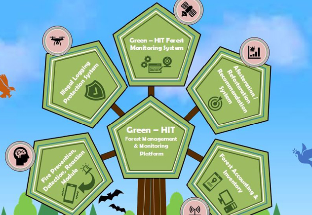
Within the framework of Green-HIT, a holistic IoT (Internet of Things) Platform for forest management and monitoring will be developed, aiming at supporting (a) prevention, detection, and reaction to forest fires, (b) afforestation and/or reforestation recommendations, (c) protecting forests from illegal logging and hunting, (d) monitoring forests and forest areas, and (e) forest mapping and inventory by collecting, combining and analyzing field data and remote sensed data.
“Our aim through this project is to fundamentally transform how forests are managed and monitored, supporting forest departments and dependent communities, scientific communities and regulatory authorities.
We will also be able to enhance the effective collaboration between enterprises and the research community. Our consortium will utilize and improve existing links and synergies in order to develop a new cost-effective solution to address forest management challenges”, explains Dr Andreas Constantinides, Associate Professor at the Department of Electrical Engineering, Computer Engineering and Informatics and Lead Researcher at the Mobile Devices Laboratory (MDL).
Frederick Research Center will drive the R&D activities utilising state-of the-art knowhow and technologies in Web and Mobile Computing, Big Data Management, Machine Learning and Optimization.
Partner ECoE, with expertise on Earth Observation, Space Technology and Geospatial Information, will contribute to remote sensing and satellite image processing/analysis.
CERIDES will contribute to the intelligence modules, focusing on fire probability calculation for prevention, fire detection, and fire reaction by simulating a fire’s behavior.
CyRIC represents the business strand of the consortium and will significantly contribute to the project’s R&D (leveraging its expertise on IoT sensors and actuators, UAVs and LoRaWAN communication), dissemination and exploitation activities.
Finally, IACO, with expertise on management plans of protected areas, will lead the categorization and selection of the pilot sites, as well as the environmental remote sensing and field data required for the project.
